Capitol Reef National Park
About Capitol Reef
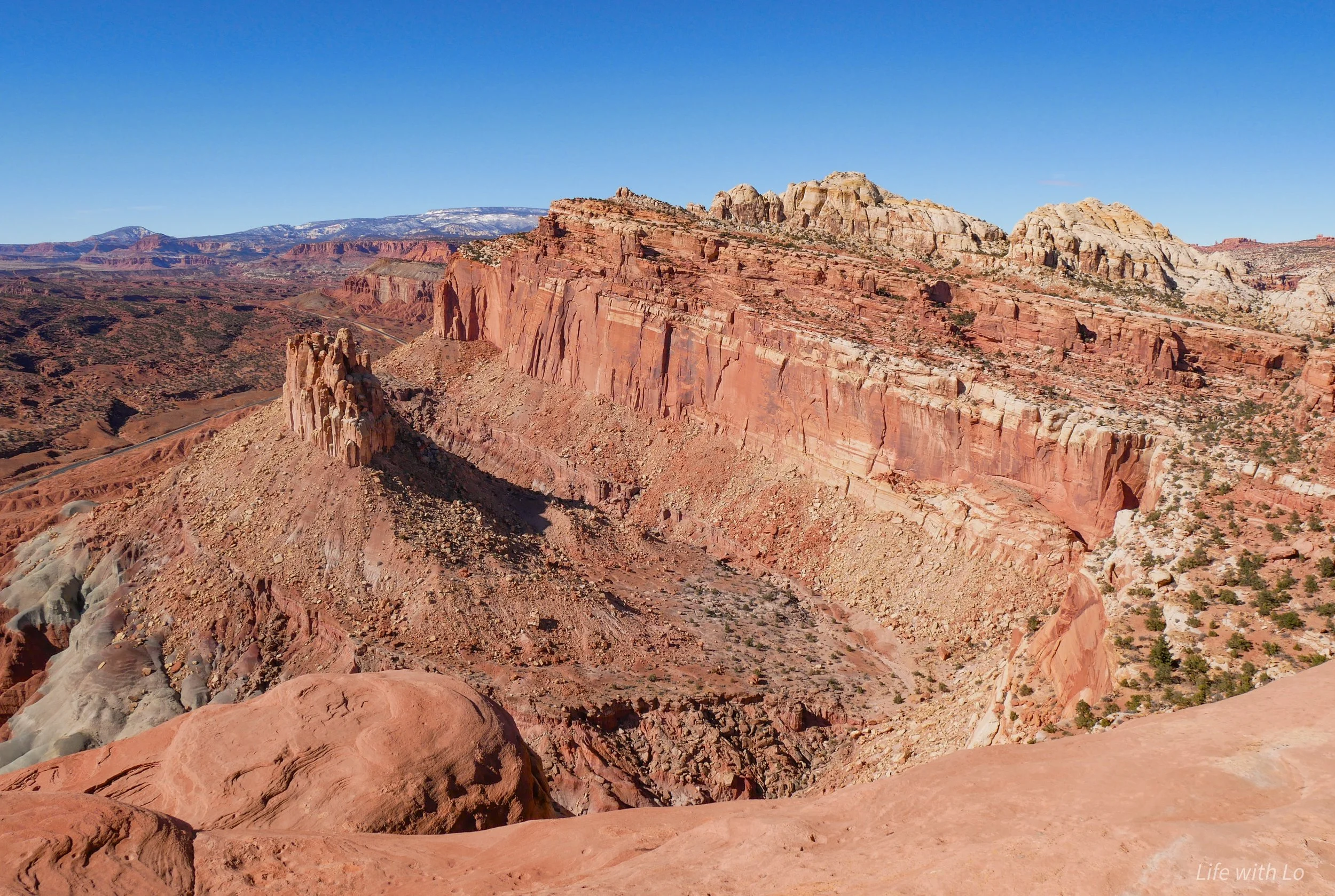
Capitol Reef National Park is located in central Utah in between Bryce Canyon and Canyonlands National Park. Capitol Reef is known for its geologic feature called a waterpocket fold that creates the beautiful formations in the park. Layers of sediments stretching 100 miles were piled on each other over millions of years. Pressure from tectonic plates created a fault in the area leading the sedimentary layers to bend around it creating the “fold”. The layers were then eroded by water creating unique features such as domes, arches, and cliffs. Capitol Reef also has a rich history of human use dating back 100s of years. The longest known running residents being the Fremont People who lived in the area from 300 to 1300 CE.


What to Do?
Go on a Hike
There is a wide array of hikes to choose from in Capitol Reef. These are the hikes that we went on and really enjoyed.
Sunset Point: 0.8 miles roundtrip. A short easy trail that brings to a spot that overlooks the canyon below. As the name states this is a great spot to watch the sunset (but due to this it is a very busy trail at that time).
Capitol Gorge (The Tanks): 2 miles roundtrip. This is a small hike that takes gives you an easy opportunity to explore beyond the road. Along this route there are petroglyphs etched into the cliff faces and waterpockets known as tanks.
Cassidy Arch: 3.4 miles roundtrip with an elevation gain of 670 feet. This trail takes you to a natural arch named after Butch Cassidy an outlaw in the late 1800s.
Rim Overlook: 4.6 miles roundtrip with an elevation gain of 1,110 feet. A strenuous hike that gives panoramic views from the canyon rim.
Navajo Knobs: 9.4 miles roundtrip with an elevation gain of 1,620 feet. This is a continuation of the Rim Overlook trail. This trail takes you to see more areas of the park from above, including the geologic feature known as The Castle.


Experience the Expansive History
There is no shortage of interesting history here in the park and evidence of this can be found throughout the area.
Petroglyphs: Located just off the main road is a panel of petroglyphs made by the Fremont People. The petroglyphs range from human figures to animals to geometric shapes.
Fruita Schoolhouse: In the late 1800s the area now know as Fruita was settled by a group of Mormons. The remains of the one room schoolhouse built in 1896 still stands.
Oyler Mine: Right off of the scenic drive there are the remains of old uranium mines from the mid-1900s. The mines themselves are boarded up so there is no access into them, but this is a cool remanent of the past.

International Dark Sky
Capitol Reef National Park is considered an international dark sky reserve. This means that there is minimal amount of light pollution in the area and on clear night skies you can see thousands of stars. In a world where light pollution has been an ever increasing problem it is a rarity that you are able to see many stars, yet alone the milky way. If you are visiting this park I highly recommend staying out past sundown to see just how incredible the night skies are here. My recommendation would be to go to sunset point and stay an hour or two past sundown.
Where to Stay?
The closest town to stay in is Torrey, Utah. This is a small town that has a few places to stay/eat and is just a few miles south of the park entrance. If you are planning a multi park visit in Utah and prefer to have a home base another option is staying in Moab, Utah. From Moab, Capitol Reef is about two hours away, so this would be a full day trip. Moab is located in southeast Utah near Arches National Park and Canyonlands National Park.
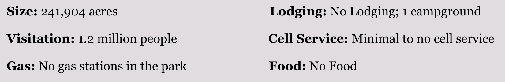
Quick Facts: